☰
Noida Master Plan 2031: A Sneak Peek Into The City's Exciting Future
A master plan is a detailed, long-term conceptual layout of a region's future growth and development. It is a planning document that includes analysis, recommendations, and suggestions for the region's economy, population, land use, transportation, and infrastructure.
The master plan determines the future development, policy, and implementation directions. Along the same lines, Noida Masterplan 2031 has been a talking point for its master vision for evolution and growth, especially for investors and end-users looking to buy commercial and residential properties in Noida.
However, Master Plan 2031 is not Noida's first or second; its history can be traced back to the 1970s.
Background
NOIDA (New Okhla Industrial Development Authority) was created under the UP Industrial Area Development Act 1976. It was envisioned as a planned satellite city of Delhi to manage the growing urban population.
The first master plan was prepared for 1991 but underwent significant changes until the revised plan was finally approved in 2001.
Initially, the focus was on establishing residential sectors, commercial areas, and industrial zones. With time, the master plan evolved to include modern infrastructure, improved connectivity, and green spaces.
Meanwhile, Noida became part of the Delhi Metropolitan Area (DMA). The city transformed into an independent urban hub from its initial status as a simple extension of Delhi.
This development enforced considerable changes to the area's land-use pattern and socio-economic profile, making it imperative that the 2001 plan be reviewed. The final master plan was eventually introduced in 2011, with subsequent plans for 2021 and 2031.
Objectives of the Noida Master Plan 2031
Noida's Master Plan 2031 has the following objectives-
Sustainable Development - The promotion of sustainable development is one of the main goals. The focus is on the importance of green spaces, environmentally friendly transportation, and effective waste management. Noida tries to find a middle ground between environmental conservation and urban development. The plan focuses on reducing carbon emissions and preserving natural resources.
Infrastructure Development - Noida's infrastructure will be upgraded substantially to align with population growth and business activities. The plan covers the development of roadways, upgrading public transport systems and updating utilities, including sewage and water delivery systems. Such infrastructure projects are designed to facilitate connectivity in the city and relieve traffic congestion.
Commercial & Industrial Growth - Noida has attracted numerous global firms and industries due to its strategic position and accommodating business environment. The Master Plan 2031 encourages the setting up of IT parks, industrial complexes, and commercial hubs to catalyse economic growth, stimulate the local economy, create more employment, and promote commercial properties in Noida region.
Affordable Housing - Noida's development initiatives aim to provide affordable houses for everyone. By this aim, the Master Plan encourages the building of affordable homes for low- and middle-income groups.
Initiatives for Smart Cities - Noida aspires to be a smart city by integrating innovative technologies, better public services, and governance. Smart transport schemes, e-governance, and digital infrastructure will complement the quality of life. In fact, smart homes in Noida are the new buzzword in the region.
Green spaces and recreational facilities - The need for additional green spaces and recreational areas is considered in the master plan for residents' well-being. Noida seeks to establish additional parks and cultural centres to foster a healthy and vibrant community.
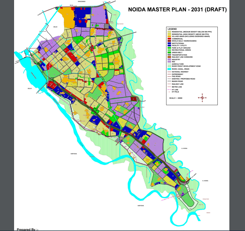
Master Plan 2031 Development Blueprint:
Land Use Pattern
Noida's layout follows a gridiron pattern. The main roads, which create a grid and divide the region into sectors, are arranged horizontally from southwest to northeast and are connected by perpendicular roads. The idea of a self-contained integrated township was the basis for the township's design.
Workplaces and high-density residential areas are adjacent. The primary commercial hub is in the city centre, and the other commercial centres are evenly spaced. The distribution of the sub-district centres considers the residential catchment areas. Residential sectors are to be developed at different densities.
Land Distribution
The current development pattern, projected growth about land suitability and other large-scale or regional infrastructure development projects, and the potential for optimal use of available land determine the distribution of land use for various purposes.
The entire land available in the city must be planned efficiently and put to a specific use. The total land proposed for planned urban development in Noida is 15,28,00,000 sq.m. as proposed in the master plan for 2031, increasing from 14,96,40,000 sq.m. as approved in the master plan for 2021.
Land use distribution in Noida as per master plan 2021 and in the proposed master plan 2031 has been shown in the following table-
S.No | Land Use Category | As approved for 2021 | Proposed for 2031 | ||
Area ( in HA) | % | Area ( in HA) | % | ||
1 | Residential | 5334 | 35.85 | 5722.14 | 37.45 |
2 | Commercial | 564 | 3.77 | 581.33 | 3.80 |
3 | Industrial | 3001 | 20.05 | 2806.52 | 18.37 |
4 | Public & Semi Public Facilities | 1219 | 8.15 | 1357.97 | 8.89 |
5 | Transportation | 2211 | 14.78 | 1942.15 | 12.71 |
6 | Recreational | 1513 | 10.12 | 2432.82 | 15.92 |
7 | Agriculture | 1017.50 | 6.8 | 332.47 | 2.18 |
8 | Water Body | 104.50 | 0.68 | 104.50 | 0.68 |
Total | 14,964 | 100 | 15,279.90 (15,280) | 100 |
The proposed land-use distribution for the year 2031 follows a hierarchical order. The total proposed urbanisable area of about 15,280 hectares has been divided into various sectors, and facilities have been distributed in almost all the areas of the town.
Population Forecast & Density
Noida's population by the year 2031 is expected to reach 25 lakhs. Given the physical and environmental aspects of the city, a vast population concentration would not be possible in Noida. Therefore, it is suggested that the population density in the already mostly built residential sections is less than 500 people per hectare. Noida has set aside several newly developed areas for group housing with a high population density and tall buildings.
Approximately 400 hectares of land is set aside in these sectors for group housing plans, with a maximum population density of 1650 people per hectare at the plot or scheme level. The Noida Authority made this deliberate choice to meet the growing demand for affordable housing in the NCR and to make the best possible and sustainable use of the residential land that is still available.
It is suggested that sectors be split into the two population density groups listed below:
More than 500 people per hectare - 45, 74, 75, 76, 77, 78, 86, 93B, 107, 112, 113, 115, 116, 117, 118, 143, 144, 151, 158, 162, 168
Less than 500 people per hectare - every other residential area.
Almost all these regions where high density is projected have large-scale green areas planned, such as playgrounds and public parks. Infrastructure facilities and services would also be built to support the increased population density.
The urban area's proposed population density is 164 people per hectare, comparable to other towns and falls well within the 150–200 pph range recommended for metro cities in the NCR – Regional Plan – 2021.
Proposed Regional Transportation links
The potential advantage of Noida's location regarding important transportation links that connect Ghaziabad and the Delhi Urban Area has led to a regional rail and road network proposal.
a) Proposed Regional Rail linkages- One of the proposed regional rail links in the multimodal transport system is a railway line connecting Dadri in the east and Tughlakabad in the southwest of Delhi, which will further connect the city of Noida. Locations for railroad yards and stations have been suggested in the vicinity of the village of Chaprauli.
The Mumbai–Delhi dedicated rail freight corridor will pass through Noida. For this, a proposed rail route in sectors 160 and 146 has been suggested. In sector 160, a railway station, a rail freight yard, and a logistics park are planned to meet the demand for freight transportation in Noida.
b) Metro Corridor- Metro services between Delhi and Noida City Center are currently available. The following sectors have metro stations: -15, 16, 18, 38A, 38, and 32. The expansion of Metro Service from City Center Noida to Bodaki Railway Station in Greater Noida via Pari-Chowk has been planned by Noida and Greater Noida Authority.
In Noida, there will be 14 new stations along this line. DMRC and Noida Authority are proposing additional Metro service links to be created in the third phase. There are two such possible connections. One goes from Delhi's Botanical Garden to Sarita Vihar via Kalindi Kunj, the other from City Center to NH-24 and City Centre to Greater Noida through Sector 121.
c) Proposed Regional Road Links – Two main routes have been suggested for Noida. The first is an expressway that connects the city to Greater Noida, and the second is a road in the multimodal corridor that connects it to Faridabad in the south and Ghaziabad in the north. It is planned to build a new road link between Noida and Faridabad to connect the NH-2 to the Noida-Greater Noida Expressway close to Noida's sectors 150 and 152.
By building a planned 120-meter-wide road in Greater Noida Phase II, this proposed road link will assist in connecting NH-2 with Noida, Greater Noida, NH-91, and further with NH-24 near Hapur.
New Noida Master Plan 2041
The Noida Authority has approved the New Noida Master Plan 2041 draft plan, whereby the authority seeks to buy nearly 21,000 hectares of land. The aim is to establish industries and a contemporary hub for industrial development inside the Dadri-Noida-Ghaziabad Investment Region (DNGIR), which is a part of New Noida.
The plan will create Special economic zones for industrial units from the agriculture, food processing, and FMCG sectors. Additional plans exist to build integrated townships, knowledge centres, skill development centres, and logistics hubs. Eighty-four villages in Dadri and Bulandshahar will be developed by the new master plan along the lines of US and European cities like Chicago.
The New Noida township will span an area of 20,000 hectares, which would have 41 areas set aside for industrial use. 11.5% of the total has been set aside for residential construction, 17% for green and recreational areas, 15.5% for road infrastructure, 9% for institutional use, and 4.5% for commercial use.
For more on leveraging NCR's growth to buy commercial and residential properties, don't hesitate to contact us.
Contact Our Real Estate Experts
Recent Articles


Premium Office Space in Greater Noida West with Mr. 4999
July 10, 2026